


Wednesday, October 19, 2016
View the entire Google Web Album
The journey is as scenic as the destination at Point Pinole Regional Shoreline, a 2,315-acre parkland right next to densely populated Pinole, Richmond, and San Pablo. Trails lead through breezy meadows with wildflowers in season, through aromatic eucalyptus woods, or along bluffs and beaches on San Pablo Bay. There are beautiful views of Mt. Tamalpais, the Marin shoreline, and San Pablo Bay with its sailboat and shipping traffic. *1
The climate at Point Pinole, one of the park’s unique charms, is always influenced by breezes and fog from the bay and offers a cool alternative to the hot inland weather. *2
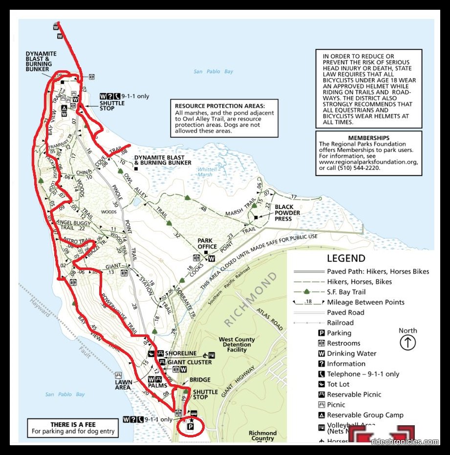
This hike travels along the west side of the Point Pinole as it crisscrosses under the shade of the fragrant eucalyptus groves from Powerhouse, Biazzi and Nitro Trails to Packhouse Trail. Explore the old concrete and wooden remnants of the explosive companies before heading out to the pier and China Cove. The return follows the scenic western shoreline with magnificent views of San Pablo Bay and beyond.
Begin this hike from the Point Pinole parking lot-head north on the paved Pinole Point Trail and cross the Paul Badger Bridge.


At the Bay View trail junction, go straight to stay on pinole Point Trail towards the pier. The paved road takes you through the picnic areas with large lawns and a children’s play area. At the Cooks Point Trail junction, go left to stay on Pinole Point Trail. It continues across the grassland towards Powerhouse Trail.


Turn left onto Powerhouse Trail, it runs northward across the upper grassland meadow towards the eucalyptus groves with views of San Pablo Bay.


The trail enters under the shade of the towering eucalyptus trees.The eucalyptus woodlands, originally planted as a buffer against potential explosions, now shelter wildlife instead, such as deer, hawks, owls, Monarch butterflies, and many other species. *1


Turn right onto Biazzi Trail followed by a left to Nitro Trail, these trails leads you to the remnant of the old foundations and concrete powerhouse used by the powder companies. Scattered, oddly shaped foundations and raised earth berms, sunken bunker areas, half buried railroad ties, and wooden pilings give you a glimpse of life at Point Pinole during the 80 years that is was home to four explosive manufacturing companies; Safety Nitro Powder Co, Granite Powder, Giant Powder Co and Atlas Powder Co. *2


Continue north on Woods Trail to Packhouse/China Cove Trail junction.


Turn left onto Packhouse Trail, it leads you out of the eucalyptus woods to Bay View Trail.


Go right onto Bay View Trail, it cuts in and out of the scattered eucalyptus stands with scenic views of the Bay. The Bay View Trail along the western shore affords easy access to the shoreline, from the flat terrain in the south to the high bluffs nearer the pier, it’s the only shoreline cliffs along this part of the Bay. *2


The trail continues north along the point past the remnants of the old dynamite blast and burning bunker.


Bay View Trail gradually drops downhill to picnic area at the south end of the pier.


Take the walk out along Point Pinole’s 1,250-foot fishing pier. Please note that dogs are not allowed on the shuttle or on the pier. Although a State fishing license is required to fish along the 5.5-mile shoreline, none is needed to fish from the pier. Sturgeon is the big quarry there; striped bass, bay rays, leopard sharks, perch, kingfish, and flounders are among the other catches of the day. *1


Enjoy the gorgeous bay views!


Exit the pier and head south through the picnic area and shuttle stop to Owl Alley Trail.


Take a short detour out to China Cove for more scenic bay views! You can even see Mt Diablo to the east!


Return north on Owl Alley to Bay View Trail.


From the overlook bench, follow the faint single track trail down to the point’s rocky shoreline.


Climb over the fallen eucalyptus and stay along the scenic shoreline.


You’ll find plenty of driftwood, old concrete blocks, bricks, shells and other marine life washed ashore.


We encountered guys flying drones for USCG trial emergency preparedness.


Exit the beach area and turn right onto Bay View Trail. The trail is part of the SF Bay Trail system, which rings the bay and it offers uninterrupted views of Pt Richmond to the south, and Mt Tamalpais, China Camp State Park, and Marin County to the west. *2


The trail continues above the shoreline with great views of the Bay and Parchester Marsh.


Bay View Trail leads you back to the bridge crossing for the return to the parking lot.


Gather friends and family for this easy hike around Point Pinole Regional Shoreline, there’s something for everyone to see and enjoy! You can also easily configure your hike around the park’s 12 miles of trails which are mostly flat or gradually sloping.
Explore sparkling bay views, driftwood-endowed shoreline, lush marshes, rolling grass meadows and shady eucalyptus groves in this beautiful regional shoreline. Discover remnants of the colorful 80-year history of explosives manufacturing on the point, which is today a state historic landmark. As you wander in the open peacefulness of this parkland, you can imagine the ranchos of the Spanish land grant era that once existed here,and the original Native American people who earlier used this area for fishing and gathering shellfish. *2
*1 http://www.ebparks.org/parks/pt_pinole
*2 Point pinol Regional Shoreline brochure
Stats:
5.44 Miles with 350′ of elevation gain
Max elevation: 37′
Time: 2.5 hours with multiple stops
Hike: Easy
Parking: Point Pinole Regional Park parking lot. $3 Fee collected when kiosk is attended on weekends and major holidays.
Water & Pit toilets around the picnic areas
Dog-Friendly with On-Off Leash areas-$2 Dog Fee collected when kiosk is attended on weekends and major holidays.
*Dogs not allowed on or around the marshes along Bay View Trail, Marsh Trail and on the pier.
Weather: Sunny and warm with clear blue skies. Temps ranged from the low 60’s to the mid 70’s with NE winds.
Check shuttle service schedule and fees
Direction: Cross Atlas Bridge > R-Pinole Point Tr > L-Powerhouse Tr > R-Biazzi Tr > L-Nitro Tr > R-Bay View Tr >R-Woods Tr > L-Biazzi Tr > R-Powerhouse Tr > R-Bay View Tr > L -Pinole Point Tr > Point Pinole Pier > U-Pier > S-Pinole Point Tr > L-Owl Alley Tr > L-China Cove Tr > U-China Cove Tr > R-Owl Alley Tr > R-Pinole Point Tr > L-Bay View Tr > R-faint trail down to rocky shoreline > L-stay on shoreline > L-Beach Access Tr > R-Bay View Tr > l-Bay View Tr > R-cross Atlas Bridge > R-Pinole Point Tr > parking lot

Your photography continues to improve with practice.
LikeLike