


Wednesday, July 27, 2016
View the entire Google Web Album
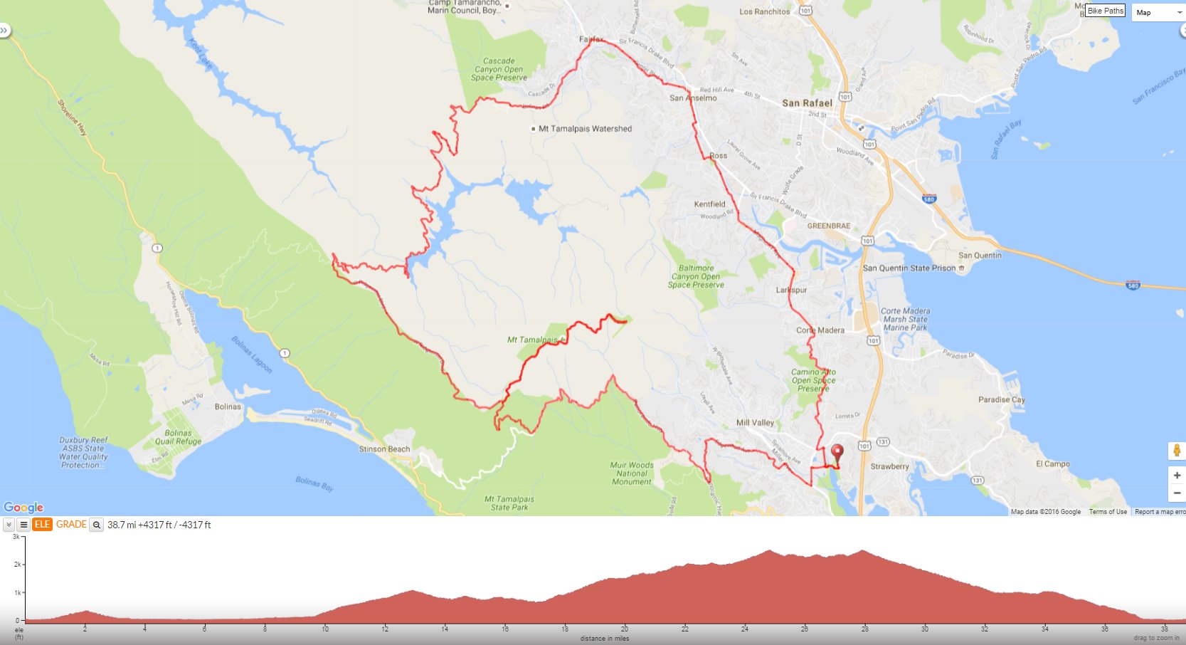
This counter clockwise loop meanders through the city streets from Mill Valley to Fairfax before climbing up Bolinas Fairfax Rd up to Pine Mountain and descending through the gorgeous redwoods to Alpine Lake. It climbs out from the lake up through the redwood forest to W Ridgecrest Blvd for the spectacular run along the top of Bolinas Ridge to Rock Springs. Continue climbing up E Ridgecrest Blvd to the summit of Mt Tam.
Begin at the Hauke Park parking lot off Hamilton Dr in Mill Valley. The multi-use path takes you across Pickleweed Inlet onto the Mill Valley-Sausalito Path heading north to E Blithedale Ave.


Contonue north with a climb up Camino Alto; it’s 1.3 miles with an average grade of 4.4% followed by a fabulous sweeping descent on smooth pavement into Corte Madera.


Meander through the city streets of Corte Madera on Magnolia Ave to Larkspur and continue on Kent and Poplar Ave into Ross.


The jog along Lagunitas Rd and Shady Ln takes you along a residential neighborhood into San Anselmo.


Marin County Bike Rte 20 weaves along San Anselmo Ave through the downtown area of San Anselmo onto Center and Broadway Blvd in Fairfax.


Head west on Bolinas Rd towards Deer Park Villa.


Turn SW on Bolinas Rd; it’s a narrow stretch of road that winds up 2.1 miles with gradient ranges of 7-11% through a residential neighborhood to the Meadow Club Golf Course.


The road name changes to Bolinas Fairfax Rd at the Mt Tamalpais Watershed sign. This quiet back road continues to climb for 1.3 miles to the road closure at Azalea Hill Trailhead with an average grade of 5%.


The road sweeps down and around into the shaded woodlands.


Bolinas Fairfax Rd narrows as it winds down through the beautiful redwoods on rolling terrain out to Alpine Lake/Dam!


Enjoy the views!


After crossing Alpine Dam, the road tilts up at the first right hairpin turn. it continues uphill on a narrow road under the gorgeous canopy of trees for the next 2.2 miles with an average grade of 7% and steep pitches of 10-11%.


After the third switchback, it’s a short 0.2 mile up to the ridge at W Ridgecrest Blvd.


Enjoy the magnificent towering redwoods!


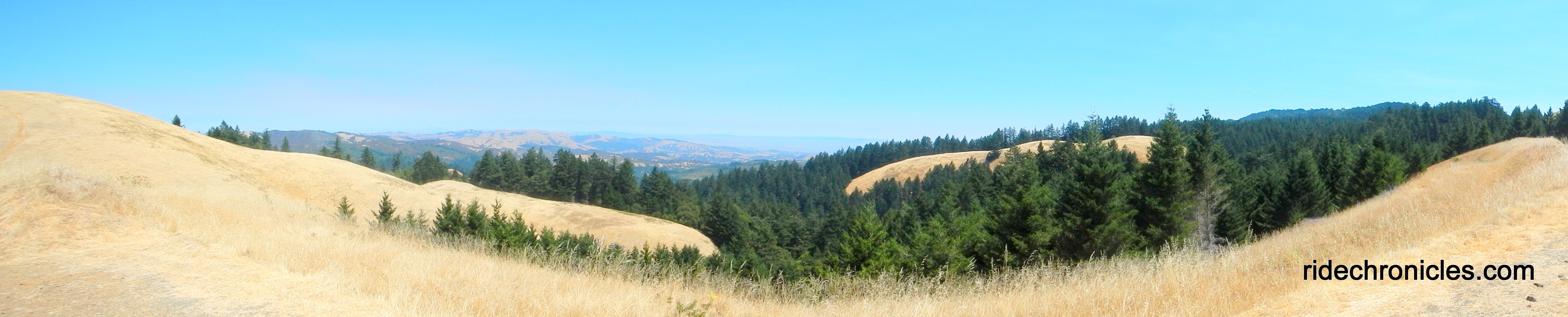
The next 3.8 miles on W Ridgecrest Blvd takes you along the gorgeous Bolinas Ridge.


Enjoy glorious ridge top vistas!


The run along the ridge towards Rock Springs consists of a series of giant rolling climbs with gradient ranges of 9-13%-enjoy the ride!


Enjoy the views!


The road continues winding around the ridge before dropping down to the parking lot at Rock Springs Trail Head.


E Ridgecrest Blvd to the summit is 3 miles long with an average grade of 6% as it snakes up around the mountain.


At the gated Air Force Station, the road kicks up with steep grades of 9-15% up to the first high point!


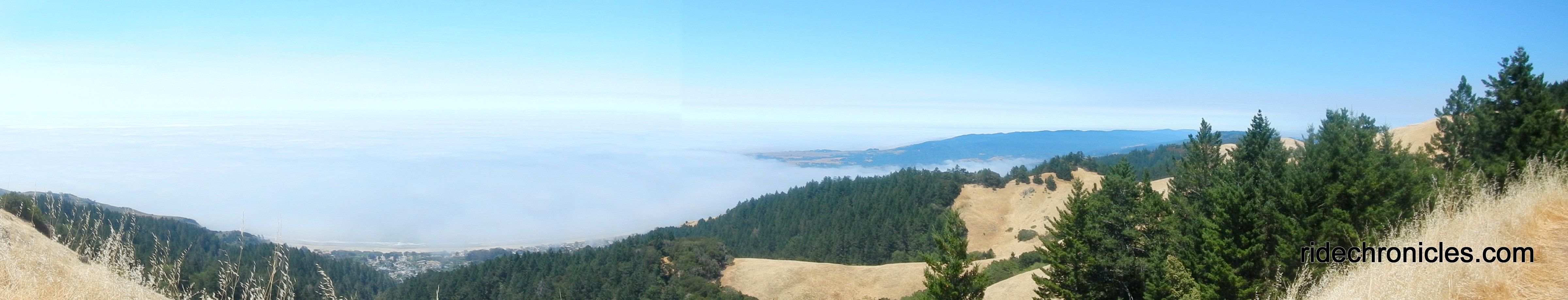
There are several vista points on the way up the mountain, pull over and enjoy the dramatic views of SF, Marin and beyond!


From the high point, E Ridgecrest continues for another 1.6 rolling miles.


The road descends onto Old Railroad Grade Trail which leads up to the East Peak summit.


Mt Tam-enjoy the phenomenal views!


To descend Mt Tam, you have to climb about 300 feet to the high point with grades of 6-10% before actually descending the mountain.


The sweeping fun descent on E Ridgecrest leads down to the Rock Spring parking lot followed by another dramatic twisty downhill on Pan Toll to Panoramic Hwy.


38.6 Miles with 4167′ of elevation gain
Max elevation: 2390′
Max grade: 13%
Terrain: Extremely hilly with steep climbs
Weather: Sunny and HOT! Temps ranged from the mid 60’s to the low 100’s with SW winds.
View the interactive RGPS route map & profile
Follow this route for today’s ride:
