Tuesday, December 29, 2015
View the entire Google Web Album
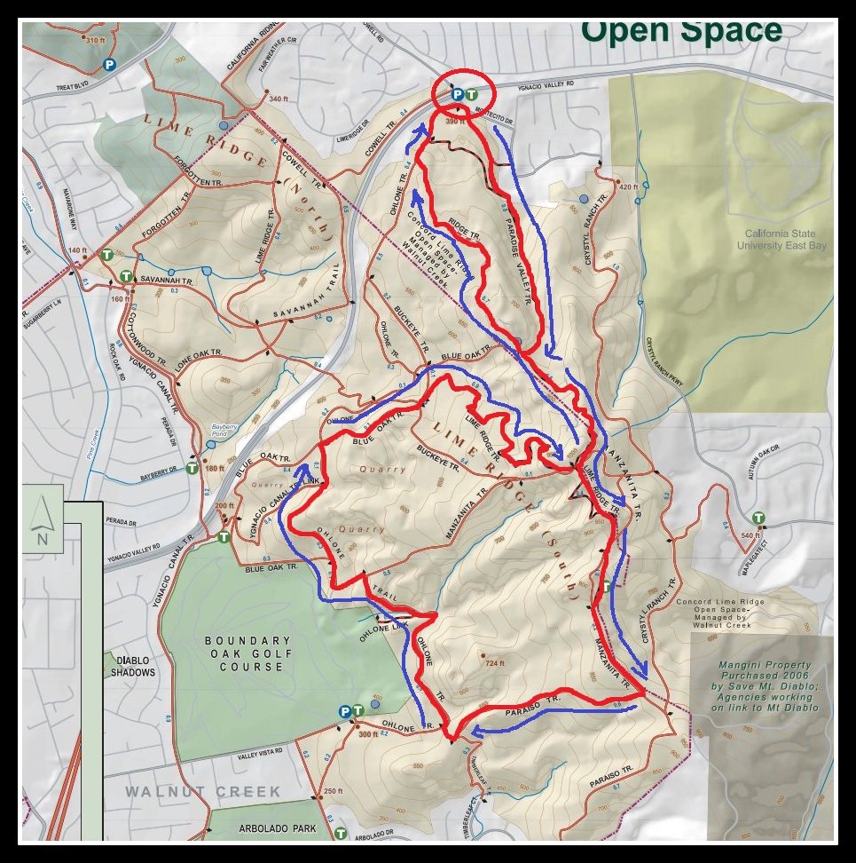
*Lime Ridge Open Space encompasses the dominant ridge leading to Mt Diablo and forms an important visual backdrop to the urbanized portions of Ygnacio Valley. It is a natural greenbelt connector between Walnut Creek and the Concord and Clayton areas to the east. The preserve contains some of the last remaining chaparral vegetation in the Walnut Creek Open Space.
This hike explore the network of trails around the rugged chaparral covered hills at Lime Ridge Open Space Preserve. This clockwise loop goes south along Paradise Valley Trail to the top of Lime Ridge before dropping down along Manzanita Trail to Paraiso Trail. It continues north on the Ohlone Trail for a scenic jaunt through the old lime stone quarry before climbing back up to Lime Ridge. Return on Ridge Trail and Ohlone Trail back to Montecito Staging Area.
Begin from the trail gate at Montecito staging parking lot.


Turn left and head up the hill on the unsigned Paradise Valley Trail.


Paradise Valley Trail goes along the east edge of the preserve through an old limestone mining area.


At the Paradise Valley junction: go right and follow the gentle single track trail through the beautiful oak woodland. The trail continues southward as it winds around through the gorgeous canopy of trees.


At the unmarked trail junction-continue left on Paradise Valley Trail; the single track climbs up from the woodland along the lower ridgeline.


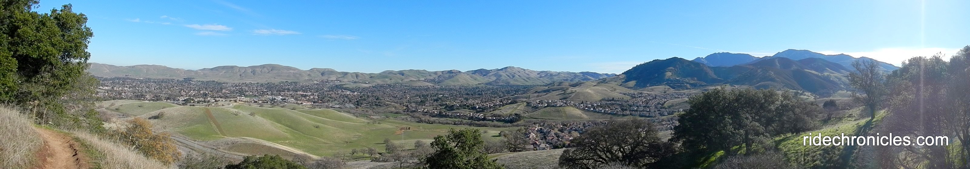
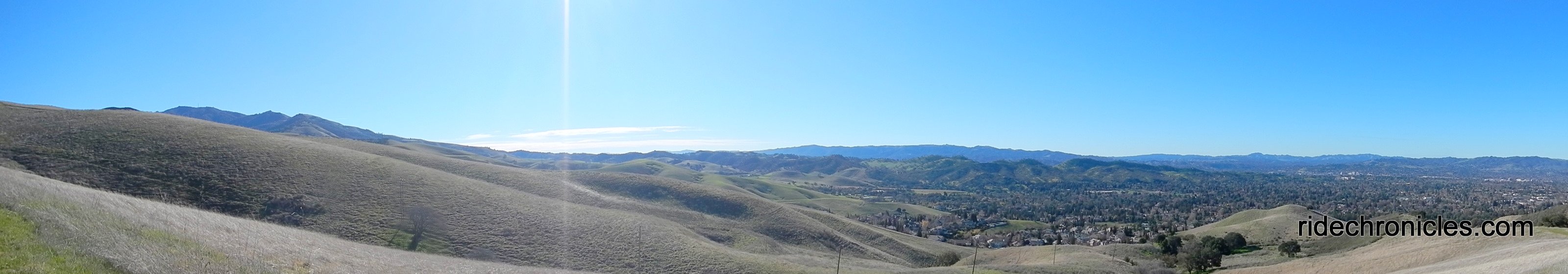
Enjoy the spectacular panoramic views of Clayton Valley and the surrounding canyons and hills east of Diablo.


The trail leads up to the flat 4-way junction at the top of Lime Ridge.


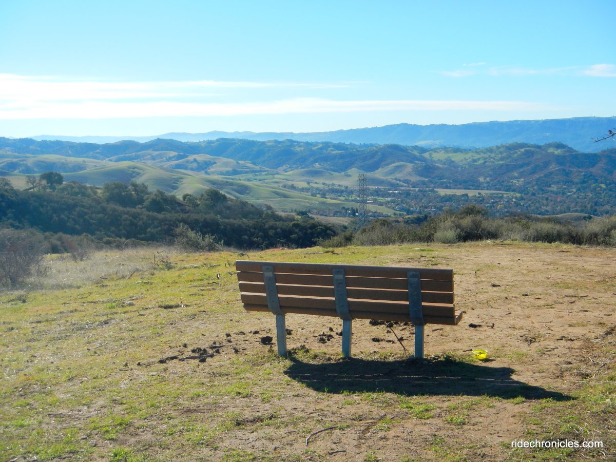
Take the short jaunt up to the vista bench and soak in the gorgeous views around the west side of the ridge; Ygnacio Valley, Brones Hills, San Pablo Ridge, San Pablo Bay and the North Bay areas!


Return to the open trail junction area and go straight along the ridge towards the transmission towers onto Lime Ridge Trail. The trail cuts through the chaparral covered hillside before dropping down through the open grasslands to the Manzanita/Lime Ridge Trail junction.


Turn right onto Manzanita Trail; it rolls along the ridge before dropping down to the cattle gate.


Continue through the trail gate onto the gentle rolling hills.


Enjoy the panoramic vistas of San Ramon Valley and Las Trampas!


Manzanita drops down from the hill to the Paraiso Trail junction.


Turn right onto Paraiso Trail; it cuts across Lime Ridge Open Space as it rolls downhill to the Ohlone Trail junction.


At the Ohlone Trail junction: turn right onto Ohlone Trail; it travels northwards along the southern section of the preserve, adjacent to the Boundary Oak Golf Course.


Ohlone Trail continues with a gentle climb up towards the lime stone and chaparral covered hills to the junction at Ohlone Trail Link.


Go straight to stay on Ohlone Trail; the broad fire trail continues below the lime stone hills to the T junction with Manzanita Trail.


Cross Manzanita Trail onto the unsigned Ohlone Trail; the gentle up hill leads towards the old lime stone quarry.


As you near the lime stone wall, the trail becomes a single track as it cuts across the grassland on semi-rocky terrain.


Views of the old lime stone quarry.


The single track continues along the hillside to an open flat top area with fabulous valley views.


The trail winds around the limestone hills as it turns eastward through the open grasslands.


Ohlone Trail goes uphill through the scattered oaks to another limestone quarry area with a small cave.


At the Buckeye/Blue Oak Trail junction: turn right onto Blue Oak Trail. The next few steps immediately leads to the next trail junction at Lime Ridge/Buckeye. Go left to stay on Blue Oak Trail to Lime Ridge Trail.


At Lime Ridge junction: go right onto Lime Ridge and head up the hill. The single track trail travels southeast through the grasslands into the woodlands.


Lime Ridge Trail exits the woodland and continues winding its way up through the chaparral covered hillside.


Enjoy the grand views along the way.


The trail reaches the top of Lime Ridge at the 4-way junction.


Go left to Paradise Valley Trail.


At the unmarked trail split-go left towards the water tower.


At Blue Oak/ridge Trail junction: turn right onto Ridge Trail. It goes up along the ridge past the water tower with great valley views!


Just past the water tower under a large oak tree, make a detour off the trail to visit “The General’s” old tombstone-it’s a grave site for a dog named General. The concrete is the remains of an old slaughterhouse.


Ridge Trail winds down through the open grasslands to the Ohlone Trail junction.


Turn right onto Ohlone Trail; it leads back to the staging area at Montecito.


This is a wonderful scenic local hike around the undeveloped foothill ridge of Mt Diablo through the woodlands and chaparral vegetation at Lime Ridge. You’ll enjoy the fabulous vistas of the surrounding ridges, canyons, valleys and Mt Diablo!
*http://www.wcosf.org/enjoy/maps/limeridgemap.pdf
Stats:
6.51 Miles with 1549′ of elevation gain
Max elevation: 974′
Time: 3.5 hours with several stops
Hike: Easy with gradual ascents and low hills
Parking: Montecito Dr parking lot at the east end of Cowell Rd on the SE side of Ygnacio Valley Rd in Concord.
Parking fee: No Fees
No Facilities
Dog Friendly-Portions of the preserve do not allow dogs-use discretion
Bring water & food/snacks
Weather: Sunny and cool with blue skies. Temps ranged from mid 40’s to the mid 50’s with NE winds
Print Lime Ridge Open Space Preserve Trail Map