


Friday, October 3, 2014
View the entire Google Web Album
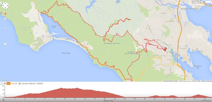
This hilly route goes up along the saddle of Mt Tam via Panoramic and Pan Toll Rd to E Ridgecrest Blvd for an out and back to the summit. It continues with a spectacular roll along the top of Bolinas Ridge on W Ridgecrest Blvd to Fairfax Bolinas Rd and Hwy 1. The scenic flat run along the Bolinas Lagoon to Stinson Beach leads to the gorgeous stretch along Hwy 1 S to Muir Woods. Return to Mill Valley with a final climb up Muir Woods Rd to Four Corners.
We head north on Miller Ave to the downtown area around Depot Plaza.


The turn on Cascade Dr takes us through the redwoods around Old Mill Park.


Marion Dr winds up along the canyon through a beautiful residential neighborhood with homes nestled in the woods. It’s 0.9 mile with an average grade of 5.1%.


Edgewood Ave continues to climb up through the neighborhoods with an average grade of 5.6%.


We head south on Sequoia Valley Rd to Panoramic Hwy at Four Corners; the climb is 0.5 mile with an average grade of 7.8%.


Panoramic Hwy runs along the east edge of Muir Woods National Monument; the rolling terrain goes along the top of the ridge with gorgeous vistas of the wooded forests. The road snakes through the hillside neighborhoods up to Mountain House Inn with steep grades of 9-11%.


Panoramic Hwy continues winding along the ridge before gently dropping down into the redwoods around Mt Tam State Park.


The road weaves up along the base of the mountain under a gorgeous canopy of pines and redwoods to Pan Toll Rd with an average grade of 6.5%.


Pan Toll Rd takes us into Mt Tam State Park; the climbing continues for 1.5 miles up to the Rock Springs parking lot with an average grade of 5.9%.


Take the time to enjoy the spectacular views!


E Ridgecrest takes us for an out and back to the summit of Mt Tamalpais; it’s a steady 1.4 mile climb up to the highest point with an average grade of 6.7% and a short steep section with grades of 12-15%.


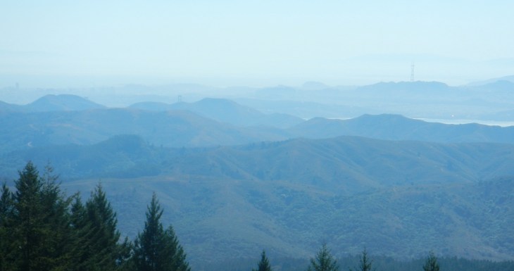
On the climb up, there are several vista points-pull over and enjoy the dramatic views of SF, Marin and beyond!
From the high point, E Ridgecrest continues for another 1.6 miles of rolling climbs before descending onto Old Railroad Grade Trail which leads up to the East Peak summit.


Enjoy the fabulous summit top views!


The descent from the summit regains 250+ feet of climbing back up to the high spot with gradient ranges of 6-10% followed by a sweeping downhill back to Rock Springs.


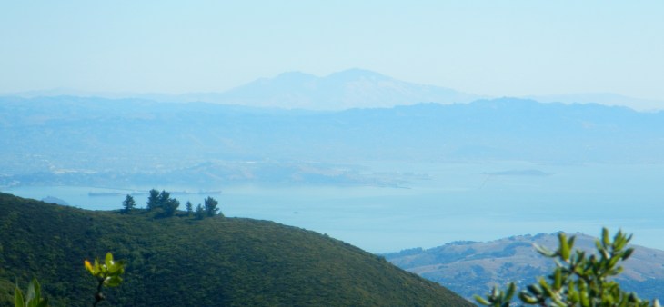
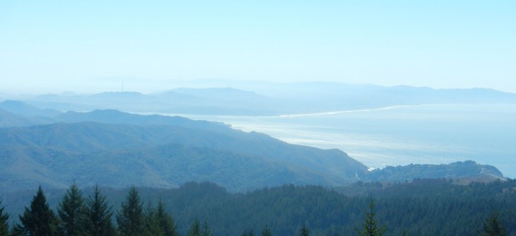
We continue on W Ridgecrest Blvd; this is one of the most beautiful roads in California! The rolling terrain on the ridge provides many opportunities to take advantage of the breathtaking views of the Pacific Ocean, Stinson Beach, and the chaparral covered ridges and grasslands.


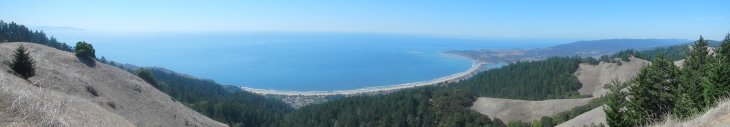
The rollers continue along the ridge to Fairfax Bolinas Rd with many beautiful vista points; stop and enjoy the spectacular views!


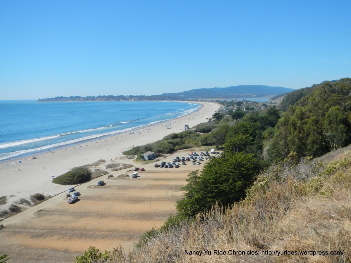
The twisty 4.4 mile descent on Fairfax Bolinas Rd leads us down onto Hwy 1 in Bolinas. The flat terrain on Hwy 1 S rolls along the scenic shoreline of Bolinas Lagoon for 4.4 miles.


Our lunch stop is at the Stinson Beach Market and Park.


Stinson Beach


We stay on Hwy 1 S for the climb up to the first high point at Steep Ravine near Rocky Point Rd; it’s 1.5 mile with an average grade of 5.5%.


Enjoy the fantastic coastal views!


Hwy 1 S continues along the coastline with a sweeping descent and short rolling climbs from Lone Tree Creek to Slide Ranch.
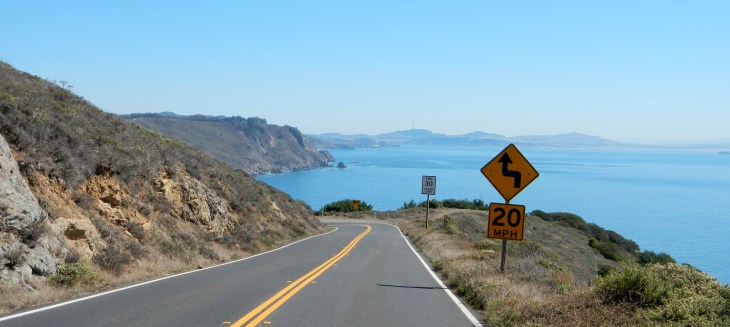


The coastal views are magnificent!


The climb from Slide Ranch to the upper ridge is 0.4 mile with an average grade of 8.4%.


Hwy 1 S continues along the ridge with marvelous views of the blue Pacific and coastal mountains!


Hwy 1 S winds down along the edge of the Golden Gate Nat’l Recreation Area to Muir Beach. We head NE through the scenic Frank Valley on Muir Woods Rd to Santos Meadow and the park residences at Mt Tam State Park.


The road winds around the valley to the entrance to Muir Woods National Monument.


Muir Woods Rd to Four Corners is a steady 1.5 mile climb with an average grade of 7.1%. The first 0.7 mile going up around the switchbacks along the shaded Redwood Canyon has steep grades of 10-13%.


At the mailboxes on Camino del Cyn, the road eases down to lesser grades of 6-9% and kicks back up again to steep grades on the way around the last switchback. Muir Woods Rd continues up along the back ridge with lesser grades and fabulous mountain and forest vistas!


At Four Corners, we descend Sequoia Valley Rd to Edgewood and take the bike route along Janes St back to Miller Ave.


This is a gorgeous “bang for the buck” ride that centers on Mt Tam, Muir Woods, the open Bolinas Ridge and the magnificent California coastline. The effort spent on all the climbs is greatly rewarded with the phenomenal natural beauty this area provides! This is all free to us-we just have to make the time to get out there and enjoy it!
Garmin Stats:
41.71 Miles with 4921′ of elevation gain
Max elevation: 2447′
Max grade: 15%
Terrain: Extremely Hilly
Weather: Super clear skies-Sunny and warm with temps ranging from the low 60’s to the mid 90’s. NE winds with 46% humidity
Click here to view the interactive route map & elevation profile
Follow this route for today’s ride:
