


Wednesday, August 13, 2014
View the entire Google Web Album
This ride goes around the scenic back roads of Novato on Indian Valley Rd and Novato Blvd past horse ranches to Stafford Lake. The route climbs out of the lake to Pt Reyes Petaluma Rd for another stop at the Cheese Factory. It continues along the flats around Nicasio Reservoir on Pt Reyes Petaluma Rd to the lunch stop at Pt Reyes Station. Return via Nicasio Valley Rd and Lucas Valley Rd.
We begin the ride from Marinwood Community Center and head north on Miller Creek Rd.


The Mulit-use path off Marinwood Ave runs parallel to Hwy 101 with a short climb up Pacheco Hill before descending onto Alameda Del Prado.


Alameda Del Prado continues north into Novato to Ignacio Blvd. Ignacio goes through the residential subdivisions around Marin Country Club to Sunset Pkwy.


The short climb up Sunset Pkwy leads us through the older neighborhoods of Novato on Cambridge and Arthur St.


Indian Valley Rd is a quiet stretch of road that meanders through a horse ranching community.


We continue weaving our way around the different neighborhoods on Wilson Ave and Mill Rd to Vineyard and Sutro Ave.


Novato Blvd stretches 6.3 miles from Sutro Ave to the west end at Pt Reyes Petaluma Rd. The gentle rolling terrain leads us out of town to the short climb up to Stafford Dam at Stafford Lake.


The Multi-use path along Novato Blvd takes us into Stafford Lake Park with beautiful views of the lake!


We exit the park and continue NW on Novato Blvd for the stair step climbs towards Hicks Valley. The road climbs out of the lake area with 3-4% grades followed by a rolling descent through a ranching community.


The road kicks up for a steep half mile climb with 7-10% grades followed by a fast half mile descent.


Novato Blvd rolls up for another short climb before dropping down through Hicks Valley to Pt Reyes Petaluma Rd.


There is a brief stop at the Cheese Factory.


We continue south on Pt Reyes Petaluma Rd for the short climb up and over Rocky Hill to Nicasio Valley.


The flat terrain on Pt Reyes Petaluma Rd goes around Nicasio Reservoir and drops down around the base of Black Mountain to the colored bridge. Some of us caught sight of the Lamborghini car club out for a ramble around Marin.


We stay on Pt Reyes Petaluma Rd and continue on CA-1 S to Pt Reyes Station.


Lunch stop at West Marin Commons:


We reverse our way out of Pt Reyes Station on CA-1 N back to Pt Reyes Petaluma Rd.


The climb up to the spillway takes us back along the flats around Nicasio Reservoir.


From Nicasio Valley Rd, the lack of water in the reservoir reveals the old Nicasio Bridge.


The short rise on Nicasio Valley Rd takes us up and over into Nicasio with beautiful country valley scenes; wide open hills, grazing cattle, the old historic Nicasio School and the giraffes inside the Nicasio barn.


The flats through the redwoods on Lucas Valley Rd lead us out to the gentle climbs up to Big Rock summit.


Only this time, we didn’t have the chance to reach Big Rock. At 3838 Lucas Valley Rd, car and bike traffic comes to a halt. A CHP officer was sending all eastbound cars and cyclists back around due to an overturned big rig on Lucas Valley. Tow trucks were in the process of hooking winch cables across the entire road to recover the full length trailer which slid down the embankment. Lucas Valley Rd would be closed for at least the next couple of hours.
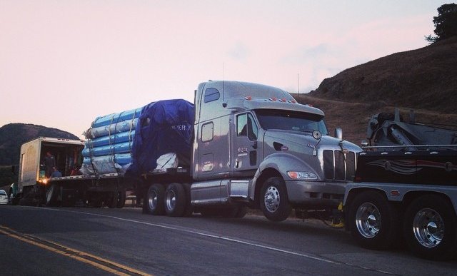
Recovery of big rig & trailer on Lucas Valley
Eleven of us got caught up in this big mess; previous groups of cyclists had gotten through a bit earlier before the total road closure. Time wise it was about 3 o’clock maybe?-Wyatt and I opted to return via Cheese Factory and Novato while a few others returned via Fairfax. Some people chose to just wait it out. The road was finally reopened at 5:45 PM and everyone was accounted for thereafter.
Life is full of adventures-we just have to go with the flow and roll with it! Due to the detour, we added an unexpected 25 miles to the original route distance of 49 miles-it’s all good!
Garmin Stats:
74 Miles with 3586′ of elevation gain > extra miles from taking detour
Max elevation: 465′
Max grade: 10%
Terrain: Rolling with a few low hills
Weather: Partly covered skies with afternoon sunshine and warm temps ranging from the mid 60’s to the high 80’s. Breezy SW winds with 73% humidity.
Click here to view the interactive route map & elevation profile

Follow this route for today’s ride:
