


Sunday, August 31, 2014
View the entire Google Web Album
Today’s route heads east towards Livermore Valley on Highland Rd to N Livermore Ave. It goes up Altamont Pass through the windmill farms to Grant Line and crosses I-580 on Midway Rd. It continues on Patterson Pass Rd for the long remote climb up the east side to the summit. The route drops back down into Livermore Valley and returns west via Portola Ave and Collier Canyon Rd.
We begin this ride from Osage Park at the end of Brookside Dr in Danville. There’s something to be said about life in the suburbs; there’s always well maintained parks within the neighborhoods with ample parking and clean restrooms.


The turn on Sycamore Valley Rd takes us along the valley through the subdivisions around Danville to San Ramon onto Camino Tassajara. Camino Tassjara continues through the burbs along the south edge of the gated community in Blackhawk.


The road exits town and heads out towards the country with wide open pastoral ranch lands and rolling hills through the unincorporated town of Tassjara.


Highland Rd travels east on gentle rolling terrain through “horse country” with boarding ranches and training facilities. The beautiful golden hills are dotted with grazing cattle and scattered barns.


The short climb up on Highland has gradient ranges of 3-6%; it takes us out along the valley farms and ranches on false flat terrain before dropping into Alameda County onto Manning Rd.


We hit the flat lands on Manning Rd to N Livermore Ave and side step through the open scenic Livermore Valley on May School, Dagnino and Raymond Ave to the edge of Springtown in Livermore.


Broadmoor and Scenic Ave cuts through the neighborhoods to Herman Rd; this leads us onto Northfront Rd which runs alongside I-580. The road name changes to Altamont Pass Rd and continues east pass Greenville Rd and the Club Moto Motorcross track.


Altamont Pass Rd goes under the UP train trestle and ascends with minimal traffic on rolling terrain with gentle gradient ranges of 2-3.5% for the next 3.2 miles to the top at the Summit Garage.


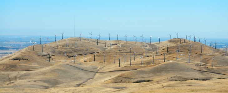
The rolling descent on Altamont Pass Rd to Grant Line Rd is quite scenic and fun; windmills dot the landscape as we pass through the Altamont Pass Wind Farms along the Diablo Range.


We head south on Midway Rd along the California Aqueduct and cross under I-580 through a small ranching community.


The road climbs up with 4-7% grades towards the closed Altamont Speedway before dropping down into the valley to the Altamont Pass Wind Farm Substation.


Patterson Pass Rd is a quiet less-traveled remote back road; from Midway Rd, it stretches east to west along the Diablo Range for 11.5 miles into Livermore.
The climb begins as you round the substation to Mulqueeney Ranch; it’s 3.1 miles with an average grade of 4.8% up to the Patterson Pass Windfarm.


From the windfarm, the road kicks up with steep grades of 9-11% for 3/10th of a mile as it winds around the hill and levels out at the false summit.


Look ahead and you can see the infamous section of this road leading up to Patterson Pass; aka “Oh-My Gosh” summit on the course of Devil Mountain Double.

Oh-My-Gosh summit
It’s really not as bad as it looks; the road dramatically tilts up and stair-steps for the next 0.8 mile with an average grade of 7%.


The last 0.2 mile up to the summit is the steepest section with 12-16% grades!


Enjoy the stunning valley views from the summit and check out the road that got you there-WOW!


Patterson Pass Rd quickly descends along the back side of the ridge to Cross Rd and continues winding down the valley into Livermore.


We stay on Patterson Pass Rd pass the Lawrence Livermore National Laboratory and Industrial Business Park area to Vasco Rd. The road enters a residential neighborhood which T ‘s at the end with Mines Rd.


Mines Rd takes us across an overpass to our lunch stop at Safeway in the Shopping Plaza off First St.


We continue east on First St and make our way through Livermore on Portola Ave; this road leads us out of town and over I-580 to the newer subdivisions around Las Positas College and Collier Canyon Rd.


Collier Canyon Rd is another quiet less-traveled road; it stretches 5.5 miles on gentle rolling terrain from the south end in Alameda County to the north end at Highland Rd in Contra Costa County. The gentle rolling terrain goes through a horse and cattle ranching community.


Grazing cattle and horses dot the landscape along with old farm equipment and weathered wooden barns.


The canyon has several horse boarding facilities with large paddocks and pastoral lands.


At the intersection with Carneal Rd, Collier Canyon climbs gently for about a mile with grades of 2-4.5% up to the old water tower and windmill. The fast descent drops us onto Highland Rd.


At Highland Rd, we reverse our way back out to Camino Tassjara pass the equine boarding and training facilities and open pastoral fields below the contoured hills to the suburban neighborhoods around Blackhawk.


On the return through Sycamore Valley, we never had to put a foot down and amazingly crossed through all the green lights from Tassajara back to Osage Park in Danville-that’s a first!


This wonderful ride heads out from the suburbs in Danville to Livermore Valley and through the remote less-traveled back roads and windfarms along the Diablo Range. The climb up to Patterson Pass is not a give-me but you’ll be greatly rewarded with the spectacular valley views and summit vistas! The windmills are out there for a reason; it’s a good idea to check wind conditions before tackling this route.
Garmin Stats:
66.26 Miles with 3136′ of elevation gain
Max elevation:1491′
Max grade: 16%
Terrain: Moderately Hilly with one long climb and a steep section on Patterson Pass Rd
Weather: Sunny and hot with temps ranging from the high 50’s to the mid 90’s. Brisk SW winds with 68% humidity.
Click here to view the interactive route map & elevation profile

Follow this route for today’s ride:

Hi Nancy
Great images and you are looking well. Your riding partner doesn’t say much though Hee hee
I am going to pass this along to a person who had a blog and does the same types of rides only without photography or the vertical aspect. He is known as texbiker.net if you want to visit .
James, Thanks-Michael is the best riding partner anyone can have-he does have the ability to talk a lot 🙂 Thanks for the info on the other blog-I’ll check it out! Happy riding! Nancy
LikeLike
Thank you. I live in Livermore and got to see stuff I haven’t accomplished on my bike yet! My husband and I are wondering how long it took.
Sara, Our saddle time was a little over 5 hours; total time was about 6 hours with a stop at the Patterson Pass summit and Safeway. From Livermore, you can do a relatively flat loop out to Collier Canyon and Livermore Valley or an out and back on Altamont Pass. Give it a try, you’ll be surprised at how much you can achieve-remember to have fun! Nancy
LikeLike
Thanks, Nancy! Great pics. I like the idea of posting the times, approximately, the rides will take. Gives us more incentive to plan to do these ‘excursions’ in our wonderful cycling area! jim
Jim, Everyone should ride at their own comfort level, a person can easily calculate their approximate overall time by dividing total miles by average mph. Nancy
LikeLike